
Motorola Defy Satellite Link
3.7Editor score
Compact smartphone companion
Two-way satellite messaging
One-button coordinate check-ins
SOS assistance available
The best locator beacon for hiking the PCT guide compares ten satellite PLBs and communicators for emergency alerts, messaging, tracking, durability, and
A locator beacon is one of the most important pieces of safety equipment for a long-distance hiker on the Pacific Crest Trail. Cellular service is unreliable across many remote sections, so a dedicated satellite device can provide emergency signaling, location sharing, and sometimes two-way communication when conventional networks cannot reach you.
This guide compares ten personal locator beacons and satellite communicators based on the features listed for each model. The evaluation covers emergency response capabilities, satellite coverage, positioning, messaging, battery life, water resistance, portability, subscription requirements, and practical features hikers may encounter along the PCT.
The top selections illustrate three common priorities: dependable emergency signaling, a feature-rich communication platform, and a lower-cost option for hikers who want basic connectivity. Product availability, service plans, and prices can change, so confirm the current details and registration requirements before purchasing.
3.7Editor score

4.8Editor score

4.6Editor score
The comparison below highlights each product's emergency, positioning, connectivity, durability, and everyday hiking features so PCT hikers can distinguish dedicated rescue beacons from subscription-based satellite communicators.


The ACR ResQLink View RLS is a dedicated personal locator beacon built for situations in which a hiker needs emergency assistance rather than everyday connectivity. Its 4.8 rating is the highest among the listed products, and its standout feature is Return Link Service, which confirms that the distress signal has reached search and rescue authorities.
We may earn a commission when you buy through this link, at no additional cost to you.
The device supports GPS, Galileo GNSS, and MEOSAR compatibility, giving it several ways to determine location and work with the international rescue-satellite network. It does not require a subscription for its core emergency function, while the listed five-year battery life and more than 28 hours of operational life address the extended timeline of a backcountry rescue.
Its digital display, infrared strobe, and built-in buoyancy make it easier to use in varied outdoor conditions, including a PCT segment near a lake or river. The trade-off is that this is primarily an emergency beacon rather than a general satellite communicator; hikers who want daily check-ins and two-way messages should choose a more communication-focused product.
It is best for hikers who place the highest value on a direct rescue signal without maintaining a service plan. Register the beacon, carry it according to the manufacturer's guidance, and learn the activation procedure before departing. For those who want proven emergency signaling with added confirmation, the RLS is the strongest all-around recommendation in this guide.
Return Link Service provides a valuable layer of reassurance by indicating that the emergency message has been received. On a remote trail, this can reduce uncertainty while a hiker waits for rescue resources to mobilize.
The beacon is designed around government rescue satellites and does not require a subscription for core emergency signaling. That makes it a straightforward option for hikers who may carry the device for years and want it available whenever needed.
We may earn a commission when you buy through this link, at no additional cost to you.
The ACR ResQLink View PLB425 is a premium emergency beacon whose defining strength is direct transmission of a GPS-equipped SOS through the international COSPAS-SARSAT rescue-satellite network. Its 4.6 rating reflects a strong balance of ruggedness, low ongoing complexity, and dedicated emergency performance.
We may earn a commission when you buy through this link, at no additional cost to you.
Once activated, it sends a distress message to search and rescue services using the 406 MHz emergency frequency while also providing a 121.5 MHz homing signal. Global coverage comes from three satellite constellations, and the inclusion of both a bright LED strobe and an infrared strobe improves nighttime visibility for rescuers.
The unit is small, lightweight, and buoyant. Its belt clip, oral-inflation tube clip, straps, and lanyard make it adaptable to different clothing and outdoor activities. Optional 406Link functionality can send non-emergency test messages to multiple contacts, although core emergency operation remains subscription-free.
This beacon is an excellent choice for serious PCT hikers who want a dedicated rescue device without routine messaging distractions. It is less suitable for someone expecting a phone-like communication tool or live tracking during every camp. Confirm the correct registration, understand the activation sequence, and perform the prescribed self-tests before the trip.
Using the 406 MHz emergency distress signal and 121.5 MHz homing signal, the PLB425 is built around the established international rescue framework. This focused design is reassuring for hikers facing injury, illness, or severe weather far from reliable cellular coverage.
The buoyant housing and included clips make it easier to keep the beacon accessible and attached in changing conditions. Carry choices should account for the device being reachable when cold, fatigue, or injury makes fine motor movements difficult.
We may earn a commission when you buy through this link, at no additional cost to you.
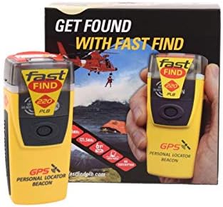
The McMurdo FastFind 220 is a focused personal locator beacon that offers a more traditional, uncomplicated approach to remote emergency signaling. Its 4.5 rating and simple activation sequence make it attractive to hikers who prioritize a dedicated rescue device over a full communications platform.
We may earn a commission when you buy through this link, at no additional cost to you.
The antenna deploys, the anti-tamper seal is pulled, and the ON button is pressed to activate it. That direct process is useful in a true emergency, particularly when a hiker is injured and has limited ability to navigate a menu. The unit can function around the world, although this listing is programmed for registration with the US country code.
Registration is legally required in most countries and is central to an effective rescue response. Personal information and travel plans may help authorities begin a search, while false or deliberate activations can endanger others and disrupt rescue services. The device is intended only for grave and imminent danger to life.
For PCT hikers who want a simple PLB and can obtain the correct US registration, the FastFind 220 is a practical choice. It is not designed for daily check-ins, detailed route sharing, or two-way correspondence. Be especially careful to activate it only when the emergency threshold has been met.
A deployable antenna, anti-tamper seal, and single control reduce the number of steps involved in sending a distress alert. Hikers should still rehearse the sequence at home so the correct action becomes automatic.
A satellite signal alone does not provide rescuers with every detail they may need. Accurate registration supplies identity and emergency-contact information, and the hiker's travel plan can help narrow the initial response.
We may earn a commission when you buy through this link, at no additional cost to you.
The Garmin inReach Mini 2 combines an emergency communicator, two-way satellite messenger, and basic navigation aid in a compact package. Its 4.6 rating makes it one of the strongest choices for PCT hikers who want to remain in contact with family throughout a long-distance trip.
We may earn a commission when you buy through this link, at no additional cost to you.
Interactive SOS reaches the Garmin Response coordination center, which is staffed around the clock to support and coordinate a rescue. Regular messaging, location sharing, MapShare updates, and weather information are available when an active satellite subscription is in place. TracBack routing can guide a lost hiker toward the starting point of a recorded journey.
The digital compass supplies heading information even while stationary, while synchronization with Garmin Explore supports planning, waypoints, courses, and topographical maps. The device can also work with compatible Garmin wearables and handhelds. Its battery can last up to 14 days in the ten-minute tracking mode, although actual life varies with settings and use.
This is the most versatile communicator for a PCT hiker who expects more than emergency alerts. It costs more to own over time because a service plan is required, and some jurisdictions regulate satellite communication devices. Choose it when regular communication and location sharing are as important as emergency response.
Two-way messaging allows hikers to send updates, ask for information, and contact people beyond cellular coverage. This is particularly useful when weather changes, a route becomes difficult, or friends and family want to know that a hiker remains safe.
TracBack, the digital compass, and Garmin Explore synchronization make the Mini 2 more than an SOS accessory. These tools complement, rather than replace, a dedicated paper map, compass, and sound judgment in trail navigation.
We may earn a commission when you buy through this link, at no additional cost to you.
ZOLEO is designed for hikers who want satellite connectivity through an existing smartphone rather than a large dedicated handset. Its 4.4 rating reflects a versatile and rugged communication approach, with text messages and email transmitted over the Iridium network when cellular service and Wi-Fi are unavailable.
We may earn a commission when you buy through this link, at no additional cost to you.
The device sends an SOS and GPS location to a 24/7 emergency monitoring center, and Medical Assist provides a non-emergency route for help. A dedicated SMS number and email address make it possible for contacts to initiate communication. Check-ins, coordinates, and optional location sharing can support trip monitoring.
Its IP68 rating supports use in harsh outdoor conditions, and the listed battery life exceeds 200 hours. The communicator also offers weather forecasts, device sharing, and support for long messages. Optional travel-risk coverage can add medical assistance and extraction support through a separate membership.
ZOLEO appeals to PCT hikers who are comfortable managing communication through an app and who want one device to handle ordinary contact as well as emergencies. The dependency on a service plan and some optional features should be considered. Keep the phone protected, charged, and accessible, and do not treat a weak phone signal as a sign that the satellite path is ready.
Using a phone for most functions makes ZOLEO approachable for travelers already comfortable with messaging apps. Hikers should still learn the app offline and carry a physical backup for battery or screen problems.
SOS and Medical Assist distinguish genuine emergencies from less urgent support needs. That flexibility is useful for PCT hikers dealing with a noncritical illness or needing advice while far from a populated area.
We may earn a commission when you buy through this link, at no additional cost to you.
The Ocean Signal rescueME PLB1 is a compact emergency beacon for hikers who want dedicated rescue signaling without a subscription. Its 4.6 rating and four-ounce weight make it particularly easy to carry, and its one-handed operation supports activation when an injury limits dexterity.
We may earn a commission when you buy through this link, at no additional cost to you.
The listed housing is 30 percent smaller than the maker's next-smallest beacon, which is helpful for minimizing pack space. A mounting clip attaches it to a life jacket or gear, while its waterproof capability extends to 49 feet. The unit includes a 66-channel GPS receiver and a one-candela high-intensity strobe.
Battery life is listed at more than 24 hours of operating life, with a seven-year battery lifespan. The device is backed by international government rescue satellites and does not require a subscription. It is intended primarily to summon professional rescue rather than provide routine updates to friends or family.
The PLB1 is a good fit for minimalists, solo hikers, and anyone who prioritizes a tiny emergency tool. It may be less attractive to hikers who want interactive messaging, weather, tracking, or a visible screen. Register it correctly, keep it accessible, and include it in realistic gear drills before the trip.
A four-ounce emergency beacon takes up very little pack space, making it easier to keep present rather than buried in a rarely opened compartment. Attachment options help it remain reachable in different weather conditions.
The 49-foot waterproof specification and high-intensity strobe add confidence near streams, lakes, and wet coastal weather. A beacon's electronics should still be protected according to the manufacturer's care instructions.
We may earn a commission when you buy through this link, at no additional cost to you.
This Garmin inReach Mini 2 Flame Red bundle combines the communicator with a USB cable, charging adapters, a car adapter, a microfiber cloth, and a portable battery charger. The 4.6-rated core device provides interactive SOS, two-way messaging, tracking, weather, and TracBack navigation.
We may earn a commission when you buy through this link, at no additional cost to you.
The communicator measures four by two inches and weighs 3.5 ounces, so it remains easy to carry on a PCT pack. Its MIL-STD-810 construction and IPX7 water resistance are designed for exposure to the elements. The included charging equipment makes it easier to maintain the device before and during a trip.
Interactive SOS is routed to the Garmin Response coordination center, which is staffed 24/7. Annual and month-to-month satellite airtime options allow hikers to choose a plan that fits their usage. Battery life reaches up to 14 days in the default ten-minute tracking mode and can extend to 30 days with a 30-minute interval.
This bundle is convenient for hikers who want a ready-to-go communication setup, especially if they also need a portable power bank. The subscription requirement remains, and a hiker may already own suitable charging equipment. Consider the included accessories against your own gear before deciding, but the core communicator remains a strong, compact option.
The cable, wall and car charging adapters, cleaning cloth, and portable battery charger cover several common charging needs. This reduces the chance of arriving at a long remote section with an empty communicator battery.
Its small dimensions, rugged construction, and water resistance suit long trail days and variable mountain weather. Water resistance is not a substitute for keeping the device dry when severe conditions are forecast.
We may earn a commission when you buy through this link, at no additional cost to you.
The renewed Garmin inReach Mini delivers the core functionality of an established satellite communicator in a small package. Its 4.2 rating is lower than the ratings of the other Garmin models listed, which may reflect its renewed status or differences in product generation rather than a lack of core capability.
We may earn a commission when you buy through this link, at no additional cost to you.
Two-way text messaging operates through the global Iridium network, and an interactive SOS reaches a 24/7 search-and-rescue monitoring center when a subscription is active. The free Garmin Earthmate app supports downloadable maps, NOAA charts, color aerial imagery, and communication with compatible Garmin devices.
Optional weather services provide detailed forecasts directly to the Mini or a paired device. The communicator can also exchange messages with compatible Garmin wearables and handhelds, making it a natural fit for hikers who already use that equipment. As with other satellite communicators, users must follow local laws governing such devices.
A renewed unit can make an established platform more attainable, but purchasers should scrutinize the condition, warranty, battery health, and included accessories. It is most suitable for a hiker who values Garmin integration and can accept a pre-owned device. Test every function before relying on it in a remote area and maintain a backup emergency plan.
Messages can be exchanged with compatible Garmin handhelds and wearables, making this a logical choice for a hiker with an established Garmin setup. That familiarity can reduce the learning burden before a long trip.
Downloadable maps, charts, and imagery are useful when cellular service is absent, but they must be saved before departure. Verify that the required map area is available and accessible on the paired device or application.
We may earn a commission when you buy through this link, at no additional cost to you.
The Motorola Defy Satellite Link offers a comparatively accessible entry into satellite messaging for PCT hikers. Its 3.7 rating is the lowest in this roundup, so buyers should evaluate the product against their need for simplicity, while recognizing that it provides the essential categories of messaging and SOS assistance.
We may earn a commission when you buy through this link, at no additional cost to you.
The device is compatible with iOS 14 and Android 10 or later smartphones. It supports two-way satellite-enabled messaging, allowing a hiker to send text content and coordinates when ordinary networks are unavailable. A dedicated check-in button simplifies sharing location with contacts, which can be valuable during a long, quiet stretch of trail.
SOS assistance can be triggered without a cellular connection, and unlimited SOS is included with every service plan according to the listed information. The satellite service itself is not free, and the product should be regarded as a phone accessory rather than a full standalone communicator with its own map display.
This is a sensible budget-oriented choice for a hiker who primarily wants short messages, location check-ins, and an SOS button without investing in a more complex dedicated device. Its limitations include the need to carry and protect a compatible phone, manage a service plan, and learn the paired application. Confirm the latest compatibility, coverage, and activation requirements before departure.
The dedicated check-in button reduces the number of steps needed to share a message or coordinates. This makes it convenient to report a campsite, trail junction, or changed condition without handling a complex interface in poor weather.
Because operation depends on a compatible smartphone, the phone must have adequate charge, storage, and a protected screen. A dead phone or damaged device could reduce the usefulness of the satellite communicator, so carry a backup navigation and communication plan.
We may earn a commission when you buy through this link, at no additional cost to you.
The ACR Bivy Stick is a satellite communicator aimed at hikers who want messaging, live tracking, offline navigation, and group coordination in one compact product. Its 3.8 rating places it behind several dedicated beacons, but its broad feature set makes it worth considering for organized or group-oriented travel.
We may earn a commission when you buy through this link, at no additional cost to you.
The device uses the global Iridium network for two-way SMS, email, GPS tracking, offline maps, SOS, weather updates, and location sharing through the Bivy app. After activation, the user receives a dedicated SMS number and email address, allowing contacts to initiate communication rather than waiting for the hiker to send every update.
Unlimited customizable GPS check-ins and live tracking are included, and GroupTrack permits messaging and location sharing with up to 12 people. The built-in GPS can track pace, mileage, and altitude, while downloaded maps and a large collection of curated adventures support offline travel planning.
Emergency SOS is monitored by Global Rescue around the clock, and the real-time location is shared when an alert is activated. The tradeoff is a subscription structure with several service levels and a broader feature set than a basic rescue beacon. It is well suited to PCT hiking groups, families, and anyone who values group tracking; ensure the service plan and app are configured before departure.
GroupTrack can connect as many as 12 people through the device, mobile app, or web browser. This is especially helpful when members of a party are separated by pace, weather, or temporary route changes.
Built-in GPS, offline maps, pace data, mileage, and altitude add useful context beyond emergency messaging. These functions should complement a paper map, compass, and practiced backcountry navigation skills rather than replace them.
We may earn a commission when you buy through this link, at no additional cost to you.
The right safety device depends on how you want to communicate, how long you will carry it, and whether you prefer a subscription-free emergency beacon or an ongoing satellite service.
In short, choose a PLB for focused emergency signaling and a communicator for regular off-grid contact.
In short, buy the correct regional version and complete registration before the device is needed.
In short, learn the exact emergency workflow and choose a clear confirmation process when possible.
In short, confirm global network compatibility but still carry independent navigation tools.
In short, prioritize emergency operating life, then choose a tracking mode that suits the trip.
In short, choose a device you will actually carry in an accessible location.
In short, match the housing to expected conditions while maintaining the device properly.
In short, prioritize practiced operation over a long feature list, and rehearse before departure.
Register the beacon according to the manufacturer's official instructions before leaving home, and enter accurate emergency contacts. Make sure the device is programmed for the appropriate country or region. Charge it fully, install or update the required application, and download the relevant offline maps. For a PLB, complete the specified self-test; for a communicator, send a test message and verify that someone receives it.
Carry the device in a location where it is protected from impact but remains accessible. Use the supplied clip, lanyard, or attachment system and periodically check that it has not worked loose. Learn the activation sequence by practicing with the safety pin, antenna, cover, or button in a controlled setting. Familiarity reduces the chance of a delayed alert, while a written reference card helps when the device and smartphone both suffer from moisture, cold, or damage.
Inspect the device after wet weather, falls, or unusually rough trail conditions. Use only approved charging equipment, keep contacts and firmware current, and follow the maker's battery-storage instructions for long gaps between trips. Never activate an emergency beacon merely to test its signal unless the manufacturer provides a dedicated test function that can be used safely. Replace the device or service registration promptly if it is lost, stolen, damaged, or no longer supported.
It is not a substitute for sound planning, navigation skills, or appropriate emergency gear, but it can provide a critical communication channel where cellular service is absent. Hikers should assess the remoteness of their route, expected exposure, group dynamics, and ability to self-rescue. Many long-distance hikers carry both a map and compass and a satellite safety device because a communication failure can become serious in an isolated landscape.
A PLB is primarily a dedicated emergency beacon that sends an alert and your location to rescue authorities. A satellite communicator is designed for routine communication and may also offer SOS, weather, tracking, maps, and two-way messaging. A PLB generally offers a simpler emergency workflow, while a communicator is more useful for ordinary updates and coordination, usually with an active service plan.
Several dedicated PLBs, including the ACR models and Ocean Signal rescueME PLB1, do not require a subscription for their core emergency function. Satellite communicators such as Garmin inReach, ZOLEO, Motorola Defy Satellite Link, and ACR Bivy Stick require service plans for their listed network features. Optional monitoring, tracking, weather, or travel-risk services may also have separate terms, so check the current plan structure before buying.
Use the official registration process supplied by the beacon manufacturer or the relevant national maritime or search-and-rescue authority. Registration connects the device to the owner's identity and emergency contacts and may record a trip plan. Do not rely on a seller's informal setup alone, and update the registration whenever the owner, contacts, or travel details materially change.
It can support navigation by displaying location, headings, tracks, waypoints, and downloaded maps, but it should not be the sole navigation resource. Screens, batteries, buttons, and satellite reception can all be affected by weather, damage, or power loss. Carry a paper map, compass, route plan, and the skills to use them, and use the electronic device as an additional source of information.
Keep it protected from impact and weather but easy to reach without unpacking the entire bag. A top pocket, belt attachment, life-jacket clip, or secure lanyard can work depending on the device and activity. Confirm that the chosen method will not let the unit fall behind or be lost during a scramble or river crossing, and keep it accessible even while sleeping in a bear-resistant area.
These products are designed for broad satellite coverage, but terrain can obstruct reception, and device performance can vary with conditions. Give the beacon a clear view of the sky when testing or activating it, and do not delay a true emergency while waiting for a perfect signal. The listed models use international rescue systems or Iridium connectivity, making them suitable for remote travel when properly registered and maintained.
Follow the manufacturer's recommended self-test schedule and always perform one before a multi-day trip. Confirm that the battery is charged, the indicator behaves correctly, and the application or emergency contacts are current. Use only the designated test procedure; deliberately sending a false distress alert can divert rescue resources and may carry legal consequences.
The ACR ResQLink View RLS stands out as the most complete emergency beacon because it combines dedicated rescue signaling with Return Link Service, global positioning support, and no requirement for a core subscription. The ACR ResQLink View PLB425 is another strong rescue-focused choice, while the Garmin inReach Mini 2 leads the communicators for two-way messaging, interactive SOS, and location sharing.
Your decision should reflect how you will use the device. Choose a compact PLB when emergency signaling is the priority, a satellite communicator when routine contact and updates matter, and a phone-linked product when simplicity and lower hardware complexity are most important. Also prioritize correct regional registration, an accessible carry method, realistic battery management, and a practiced activation procedure.
Product details, service plans, and prices can change, so verify the current specifications and terms with the manufacturer or retailer. Regardless of which model you select, register it, test it, carry it where it can be reached, and pair it with independent navigation skills and sound backcountry judgment.